Earthquakes in Arkansas May Be Man-Made, Experts Warn
Update : FCC: Presidential emergency alerts to be tested
Top 100 items that dissappear in an Emergency
Recently in February of 2011 America faced a massive blizzard, shutting down cities and towns,
crippling rush hour traffic. Not seen last since 1979 Never has a Blizzard hit the United States so hard.
Was it a natural storm or was it a created Storm?
Well all you need to do is look at the facts, and then simply connect the dot's.
Here is the Offical NASA Satellite images of the blizzard of 2011 NASA SPACE IMAGING
To me it appears that there is a spiral center located just off the coast of Florida by Cape Canaveral, which also happens to be where the Sharks Migrated to. The spiral goes out as far as Kansas and Wyoming, there is a second spiral coming against it from HAARPS direction, sort of like it is pushing it.
When Arecibo is turned on and it emits circular electromagnetic pulse/'s which would be opposite polarity of the clouds. The clouds would be attracted to the beam thus creating a circular pattern in the sky. Chemtrail metallic particulates like Aluminum, mercury, barium would be attracted to an electromagnetic pulse. In the 70's we got reports from the Bermuda Triangle that in some cases a Vortex was seen, as well as a storm came out of nowhere, plus all our power electric went out along with compasses an navigational equipment

We will start off with the Radar for the Storm system. Please watch this video Below
Now that was and Interesting video but check out this Video from an actual television weatherman, reporting the same thing.
However, this video below was covering January, 1st the first Fresh Water(Drum)fish and Bird kill in BeeBee, Arkansas
Here is another video confirming the other two Radars
Now we decided to see if HAARP was running during the blizzard if you look at HAARP Magnetometer Data and match up times and dates
you will see that HAARP was turned on at about 8pm Sunday, Jan 31st and was shut of at 12 noon Feburary 2nd. Now the time on the
chart is in UTC or Universal Time in which in Alaska you Minus 9 hours so then that means HAARP was actually turned on at 11 am
Monday morning Jan 31st and was shut off at 3am Feburary 2nd. I believe they could have possibly used either Cell Towers or GWEN Towers
to bounce the signal and push the storm The odd thing about the animal and bird kills are that the
birds are Songbirds and The fish Use EMF to detect prey as well as
Communicate to each other. The signal from HAARP
or possibly it's sister satellite Arecibo Observatory in Puerto Rico just could be responsible
for the recent
shark Migration spotted in the Palm Beach area of Florida. I Drew a line from Arecibo toward Guy Arkansas and the line comes right across where these sharks migrated as well as where the center of the circles appears to be in the above NASA Radar Image
If you go to this Earthquake map and look at the dates of Jan 31st and Feb 2nd, you will see that there was earthquake activity in both places Puerto Rico and Alaska.
There was also an Earthquake for some reason not on that map in the Ozark Mountains of Arkansas above Conway registering magnitude 3, This is in the New Madrid Fault zone.
Now, if you didn't know FEMA is planning an excercise this year in the state of Arkansas, it is called NLE 2011 or National Level Excercise 2011.
Here FEMA is Urging residents to leave the New Madrid Fault zone area on their Official Website.
Recently Fema Made an outcry for freezed dried foods and MRES, enough for 14 million people.
And if that is not enough FEMA actually has a video game for children to learn what to do in case of a massive Earthquake The video is right below here
Now, it was reported in previous years that there are mass grave sites being built in Phoenix, Arizona And one even outside Chicago in Indiana,
Did you know that FEMA are preparing mass graves in US? - Yahoo ...
Now if your still not convinced is going to happen on an epic purportion then why would FEMA have all these coffins?
Also something that is unique is that May is actually the month The Tri-Lateral Commission meets up in the first week in May. They will probably ask DHS, FEMA, Police and such if they are prepared and is everything in Place.
The first week of June is always when the secretive Bilderberg's meeting and they will probably be dicussing how things will be taken care of after the major disaster as well as get assement and damage control and such.
The dates that we predict for possible dates because they total (in the globalists eyes)911, those days would be 5/4/11, 5/13/11 and 5/22/11. Because the Tri-Lateral will be meeting we more then likely can cancel out 5/4.
People connect the dots as we have here, review the footage check these links, We are not lying to you.
Possible ideas for why the globalist's might be wanting a large Earthquake to happen is for off shore drilling. If a massive Earthquake measuring magnitude 16 were to hit Arkansas it could possibly sink the land and bring the Gulf of Mexico shoreline up to Arkansas and totally submerging states of Louisiana, Mississippi, Parts of Georgia and Florida west coast as well as parts of Texas.
You see that area is rich in oil. We the people and some rich elite own the land. The rich elite cannot obtain the land from the land owner's.
The land owner knows there is oil there so won't sell. But at same time farmer doesn't have money to drill for oil. The solution is simple. If you sink the property it no longer belongs to the property owner because he cannot access it for any benefit. Once the land is submerged the rights go to,,, get this,,, Offshore drilling and you know BP is down in the gulf after it's diliberate disaster on April 20th, 2009.
Do you think this story can get any better?
House turns over shoreline and coasts to the United Nations
The United nations also owns our US National Park System watch this video below
The Government even has a bill to Federalize all waterways in America, right down to rain water in a pothole.
Don't believe me here is the bill on the offical U.S. Congress site S. 787
Last week, Bloomberg reported that Al Qaeda or al-CIA-Duh has threatened to blow up the Stock Exchange in New York CIty.
Could this be Possible?
The answer is Yes!!!
In 2005 the New York City Transit Authority went on strike for 72 hours. This left the subway tunnels wide open for the US GOVT to plant bombs underneath the NYC Stock Exchange and commit another False flag Attack.
If you look at Metro Transit's map here you can clearly see two lines run by the NYC Stock Exchange, you might also want to make a note here that is when the NYC Police decided to start there police and armmed thugs, illegally searching people in the subway tunnels and basically stopping any homeless people from going down the tracks and possibly discovering the bombs.
And since you know there are two transit stops outside the stock exchange these subway entrances are heavily guarded by great police officers, that don't suspect a thing. On the map it looks like it would the the Number 2/3 train. Heading into Brooklym the red line.
I don't know quite how to end this article other then to say do the research, look at the facts.
One thing is for certain when FEMA is doing exercises, the actual event that they just happen to be trainning for becomes real time. You might also want to note here that FEMA also likes to hire criminals.
Don't be like Hurricane Katrina victims and say , this could never happen to me. Just remember how FEMA responded to that and the national guard, Greeting homeowners with, Not medicine, not food, not even blankets and first aid. THEY CAME WITH GUNS!!!!
Tags: HAARP Arecibo Blizzard 2011 FEMA
UPDATE 2/26/2011
Christchurch, New Zealand gets rocked by 6.3 Magnitude Earthquake
On Feburary 21st, 2011, Christchurch, New Zealand was rocked by a Magnitude 63. earthquake. The Question is "Was it done by a Radio telescope or Naturally?"
New Zealand would be to the right bottom by LaTrobe

Upon my research I found that New Zealand has 2 Radio telescopes with equal capability of HAARP and Arecibo. I looked at where the location of Warkworth was in Comparasion of Christchurch I found that Warkworth Observatory was 686 miles away from Christchurch.
So I asked my self how can I measure a bounced beam off the Ionosphere?
I was told that radio telescopes bounce at a 30 degree angle, so how could I measure that because you would get a triangle to work with, whereas the beam shot is equal to the beam bounce thus giving you the mileage between the two points.
I found out through wikipedia that the Ionsphere is 300-600 kilometers above the earth, so what i did is measure the height of the ionsphere with the Convert-me .com to convert to mileage. So this would mean that the Ionsphere would be 184.6 miles high up to 372.8 miles high. I beleive the beam was shot at 330 kilometers above the atmosphere
Now to get the beam length from Warkworth to Christchurch I simply played around with the height of the ionosphere to get half the mileage/distance between the two points, looking for the 30 degree angle. My answer is simple I want half the distance between the two points being Warkworth and Christchurch to match up with the hieght of the ionosphere. Half the distance would be 343 miles into the sky and or the ionosphere.
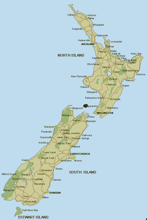
Also around the time of the Earthquake we had 120 Whales beach themselves in the Southern tip on New Zealand at Stewart Island, which the distance to Christchurch from Stewart Island is 396 miles away, keeping in mind Warkworth could bounce a beam twice, and or several times.
So we have established above that the beam was bounced off the atmosphere at 343 miles above the surface off the Earth.Is it possible when the beam hit Christchurch it then went straight, an then like a skipping stone and went toward Stewart Island or did it bounce again. Well half way between Christchurch and Stewart Island would be 198 miles. It could be possible that the beam hit full force on impact with Christchurch then only half way on its second bounce which would be kind of close to halfway as compared with 343 miles being halway between Warkworth and Christchurch.
So let's look at another example, How about Did Arecibo have something to do with the Port Au Prince Earthquake in Haiti?
As we learned Southcom as reported by CNN was caught trainning for the very earthquake scenario, by testing out its emergency radio equipment. So was the Earthquake a training drill for the military or was it a natural earthquake.
Distance between Port au Prince, Haiti and Arecibo Observatory Puerto Rico is 407 miles (See timeanddate.com)
Half the distance would be 203.5 miles, which would fit right in with the height of the ionsphere being 184.6 miles above the Earth to 372.8 miles high reach within the 30 degree angle needed to complete my triangulation theory.
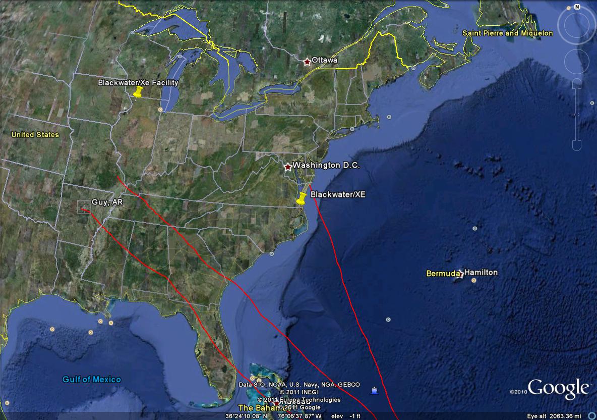
The facts are the Dominican Republic reported it did not feel any part of the earthquake. So Arecibo possibly could have shot its beam up into the ionsphere and back down again bouncing right over the Dominican Republic and hitting Port Au Prince. Now the question is can Arecibo hit Guy,Arkansas and or Beebee,Arkansas? according to GoogleEarth the distance between Arecibo and Guy,Arkansas is about 2000 miles, I beleive it is also pretty close to being 33 degrees away from each other also.
The height of Arecibo's would be 30 degree angle at 372.8 miles doubling would be 744.6 miles, or pretty close to halfway to Arkansas. Now the question is can they shot a beam that far an retain its energy, the factor is it needs something to bounce off of, if you look at the photo above of all the radio telescopes around the world you will see there is one in Wallop's island, Virginia which is exactly 1500 miles from Arecibo Observatory. My Guess is they can control the beam again when it gets to Wallops island.
Now let's see how far wallops island is from Guy,Arkansas I got 959 miles from GoogleEarth.
Now if that don't beat all the Christchurch Earthquake happen to be one 2/21/11 or numerically 232 or 322 which is a number favored by the Bohemein Grove. I look at it like this An Earthquake didn't happen in New Zealand, The globalists "destroyed Christ's Church", Ironically the day before Rahm Emmanuel stole the election in Chicago.
I also noticed that Guy, Arkansas is nicely positioned with Blackwater facilities around it, one being by Rockford, Illinois and the other one in Myock, North Carolina
Mar, 2 2011 Federal Govt Closing Off All Caves Across Country -
Expert: Chemtrails are global covert operation for total control, detecting UFOs
March 10, 2011
U.S. Urban Search & Rescue Team Deploying to New Zealand

A 7.0 earthquake in the Midwest? Planning for the "maximum-of-maximums"
Posted by: Tim Manning, Deputy Administrator, Protection and National Preparedness
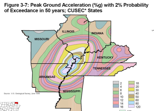
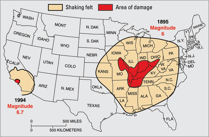
It�s the stuff legends are made of. On this day 199 years ago, the first in a series of catastrophic earthquakes rocked the Midwest along the New Madrid seismic zone. Although the epicenter of the December 16th quake was in northeast Arkansas, the magnitude of the quake reportedly caused church bells to ring along the East coast.
As the graphic above shows, an major earthquake in the New Madrid zone (of magnitude 6.0 or more) would severely affect Arkansas, Tennessee, Missouri, Kentucky, Illinois, Indiana, and Ohio. Several other states would be affected, ranging from Minnesota to Florida.
It�s hard to imagine a natural disaster on that scale today. For this reason, FEMA is leading a national-level exercise in May of 2011 (NLE 2011) simulating a major earthquake along the New Madrid fault. We�re bringing all the relevant team members to the table to make the exercise as realistic as possible � federal/state/local governments, the private sector, non-profit and faith-based groups, the public, and even the international community. FEMA leaders will provide more details on NLE 2011 as it approaches, so watch the blog for more details.
(For the emergency management types, check out an overview of Illinois�s planning for NLE 2011.)
If the 199th anniversary of New Madrid serves a purpose today, it�s that individuals and communities need to plan for what we call a �maximum of maximums� event -- a large-scale, catastrophic event. It may be gloomy to think about, but it�s necessary to plan for the unexpected, so whether you live along the New Madrid fault line or in the Pacific Northwest, take a few minutes today to be informed about the possible disasters in your community.
We sincerely hope America never has to respond to a major earthquake in the New Madrid zone, but we need to be prepared. Visit Ready.gov for earthquake preparedness tips and other ways you can get prepared.
We want to use this blog to share ideas and continue the conversation, so leave a comment about how your family / organization / company is preparing for a �maximum of maximums� event.
ALERT! HAARP STATION found! .. in Nevada lol off of MASON ROAD !! March 10, 2011
VIDEOES on FEMA and New Madrid Fault Zone along with NLE 2011
H.A.A.R.P. clouds! JAPAN QUAKE! ABSOLUTE PROOF H.A.A.R.P. WAS USED!
This video sums it all up, from pointing out Wallop's Island, to Hurricane steering, to how it can be used to create the earthquake in May 2011.
At the end they talk about how a EMP was used to created the Drought in California, as well as how it could be used against the human body, through GMO foods, the elite are actually dehydrating us through food and apparently as well with chemtrails.
One other thing this video points out is that the beam can hit the ionsphere then bounce back down into the ocean and travel through the ionized salt water, this gives good explanation on how the Bermuda Triangle could knock out boats as well as airplanes.
Now to leave you really hanging on. When humans breathe in the Particulates of the Chemtrails, such as the Barium, strontium, mercury along with a host of others. When the human body reaches a certain point on metallic elements within the physiological systems, when the HAARP, Arecibo Electromagnetic pulse is turned on, Humans could be attracted to it, thus creating the holy Bible's Rapture mentioned in Revelations. Think about it!
MORE PROOF that they intend to create a disaster, and that they know something!